Cities Below the Dirt

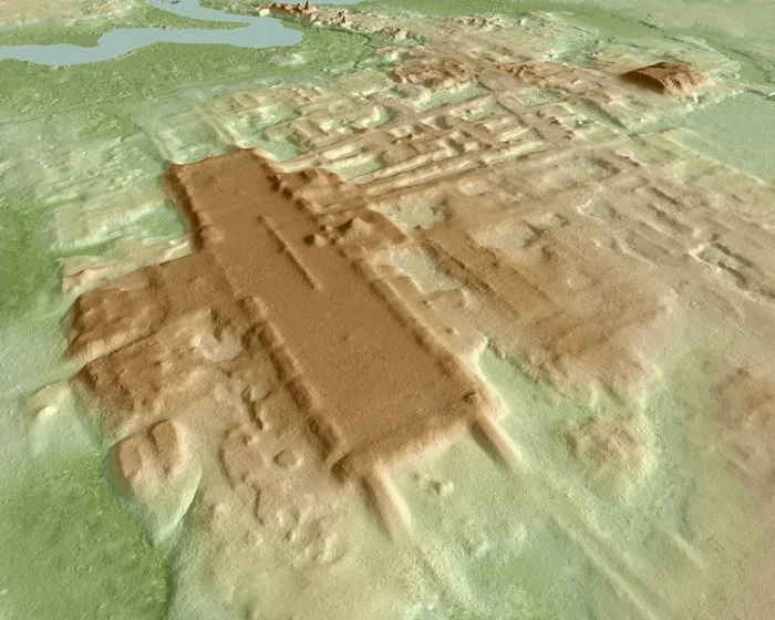
Above: The ancient Mayan structure "Aguada Fénix" in a 3D LIDAR scan. Source: Takeshi Inomata
One of the most important questions an archaeologist can ask is, "Where to dig?" It's not always easy to tell where to look when you're trying to uncover the past and sometimes digging can even damage pieces of history. That's what makes LIDAR technology so amazing; using a system of lasers, scientists can create a three dimensional map of structures buried below the ground all without even touching the soil.
LIDAR or light detection and ranging technology, allows for aerial surveying through dense forests and even under the soil. Lasers penetrate the coverage and then bounce back, giving data on what was below.
Using this technique, a team of researchers in southern Mexico were able to identify nearly 500 unique ceremonial sites dating back to the Mayan and Olmec civilizations. Some of these structures date back to 1150 BCE and evidence of their existence was only able to be discovered through this amazing technology. You can learn more about LIDAR and the new research right here!


Featured Product
Joe Frazier Boxing Glove
Latest News
-
 Nov 01, 2025 Is “Paul is Dead” Dead?: Unpacking One Of Pop Culture’s Most Enduring Conspiracy Theories Read More
 -
 Oct 31, 2025 Scientists Discover Hooves and Skin in Preserved Dinosaur "Mummies!" Read More
 -
 Oct 27, 2025 Scientists Record a Bat Catching Birds Mid-Flight! Read More
 -
 Oct 09, 2025 Scientists Discover First Fossilized Leech! Read More
 -
 Oct 01, 2025 Researchers Recreate Dinosaur Sounds Using Bizarre Instrument! Read More
 -
 Sep 19, 2025 The House that Ruth Built: The Story of the Old Yankee Stadium Read More


Cool Things!


Is “Paul is Dead” Dead?: Unpacking One Of Pop Culture’s Most Enduring Conspiracy Theories


Scientists Discover Hooves and Skin in Preserved Dinosaur "Mummies!"
A dinosaur discovery just in time for Halloween! In a new analysis of a group of fossils from Wyoming, Scientists have determined this group of fossils are dinosaur “mummies,” with preserved skin and even hooves.


Scientists Record a Bat Catching Birds Mid-Flight!
Bats, birds, screeches, oh my! In a reverse-Hitchcock twist, a new study reveals that a species of European bat catches and eats birds mid-flight.
Specimen Deep Dives


The House that Ruth Built: The Story of the Old Yankee Stadium


The Queen of the Skies: the Story of the Boeing 747


Old Ironsides: The USS Constitution and the Start of the U.S. Navy
Long Form Articles


The Artist Behind the Macintosh: Susan Kare and Apple Computers
While the two Steves, Jobs and Wozniak, are the most well known faces behind Apple computers, equally important to the products and culture of the company were those who crafted the experience of using their computers through design. The most notable of these visual architects was Susan Kare, a designer responsible for “humanizing” Macintosh computers.


Can I Lick It? Yes You Can!
Have you ever been unable to tell if a fossil was really a fossil, but you were too embarrassed to admit it? Have you ever wanted to lick a fossil just because, but you didn’t want to risk judgment from your peers? Well, good news! You can kill two birds with one stone! Licking a fossil can actually help you determine if it’s the real deal or just another rock.


Is It Legal To Own a Meteorite: How to Start Your Outer Space Collection!
Meteorites are some of the rarest geological specimens to be found on Earth. Of course, since these stones are not of our world, purchasing them can sometimes be a confusing process. Is it legal to own a meteorite? In short, yes! Read on for help starting your cosmic collection!